Of the many interesting details in Nephi’s description of his journey through the Arabian Peninsula, one of the first comes after his mention of reaching the “borders” of the Red Sea after they have left Jerusalem. It states that they traveled for three days in the wilderness (1 Nephi 2:5-6). But three days from where? Let’s consider those verses with adjacent verses from 1 Nephi 2:
[1] For behold, it came to pass that the Lord spake unto my father, yea, even in a dream, and said unto him: Blessed art thou Lehi, because of the things which thou hast done; and because thou hast been faithful and declared unto this people the things which I commanded thee, behold, they seek to take away thy life.
[2] And it came to pass that the Lord commanded my father, even in a dream, that he should take his family and depart into the wilderness.
[3] And it came to pass that he was obedient unto the word of the Lord, wherefore he did as the Lord commanded him.
[4] And it came to pass that he departed into the wilderness. And he left his house, and the land of his inheritance, and his gold, and his silver, and his precious things, and took nothing with him, save it were his family, and provisions, and tents, and departed into the wilderness.
[5] And he came down by the borders near the shore of the Red Sea; and he traveled in the wilderness in the borders which are nearer the Red Sea; and he did travel in the wilderness with his family, which consisted of my mother, Sariah, and my elder brothers, who were Laman, Lemuel, and Sam.
[6] And it came to pass that when he had traveled three days in the wilderness, he pitched his tent in a valley by the side of a river of water.
[7] And it came to pass that he built an altar of stones, and made an offering unto the Lord, and gave thanks unto the Lord our God.
[8] And it came to pass that he called the name of the river, Laman, and it emptied into the Red Sea; and the valley was in the borders near the mouth thereof.
[9] And when my father saw that the waters of the river emptied into the fountain of the Red Sea, he spake unto Laman, saying: O that thou mightest be like unto this river, continually running into the fountain of all righteousness!
[10] And he also spake unto Lemuel: O that thou mightest be like unto this valley, firm and steadfast, and immovable in keeping the commandments of the Lord!
This passage can be read in two ways. One way sees it as a description of a journey that began after reaching the Red Sea, meaning that the three days were counted after reaching the Red Sea. Another sees the journey into the wilderness as simply a continuation of the journey that began with leaving Jerusalem. After all, in v. 2, “they departed into the wilderness.” So when Nephi later writes that they “traveled three days in the wilderness,” doesn’t that mean three days total since leaving Jerusalem?
It’s an interesting question because the story either makes amazing sense or becomes ridiculous based on how one understands the three days’ journey. If the three days is counted from the initial encounter with the Red Sea, then a three-day journey by camel or about 75 miles is just right to reach a seemingly miraculous site, unknown in Joseph’s day, where a completely unexpected continually flowing stream of water exists in an impressive valley with firm, steep walls whose stream empties into the Red Sea, as described by Nephi. In other words, an seemingly ideal and very surprising candidate exists for such a river/stream of water in a place that supposedly has no such streams (except briefly after a rare rainstorm), and it’s three days from the Red Sea. That candidate, known today as Wadi Tayyib-al-Ism, provides a protected location with a good spot for an encampment that is also in just the right spot for the next leg of the journey, a four-day’s journey to the place Shazer, as described in 1 Nephi 17:
[10] And it came to pass that as my father arose in the morning, and went forth to the tent door, to his great astonishment he beheld upon the ground a round ball of curious workmanship; and it was of fine brass. And within the ball were two spindles; and the one pointed the way whither we should go into the wilderness.
[11] And it came to pass that we did gather together whatsoever things we should carry into the wilderness, and all the remainder of our provisions which the Lord had given unto us; and we did take seed of every kind that we might carry into the wilderness.
[12] And it came to pass that we did take our tents and depart into the wilderness, across the river Laman.
[13] And it came to pass that we traveled for the space of four days, nearly a south-southeast direction, and we did pitch our tents again; and we did call the name of the place Shazer.
Amazingly, the ideal encampment site in the wadi by the River Laman candidate is on the north side of the stream, and just across the stream is an opening in the walls of the canyon that one can take and travel generally south-southeast to reach an excellent candidate for the place Shazer. The opening is literally across the stream, so that one can do exactly as Nephi said, packing up (undoubtedly using camels to carry the heavy tents of the day) and just walking across the shallow “river” and then walking toward Shazer. They did not have to backtrack for miles to get back to a main trail outside the narrow canyon. See Warren P. Aston, “Nephi’s ‘Shazer’: The Fourth Arabian Pillar of the Book of Mormon,” Interpreter: A Journal of Latter-day Saint Faith and Scholarship 39 (2020): 53-72. Here’s the proposed route from the Valley of Lemuel to Warren Aston’s Shazer candidate:
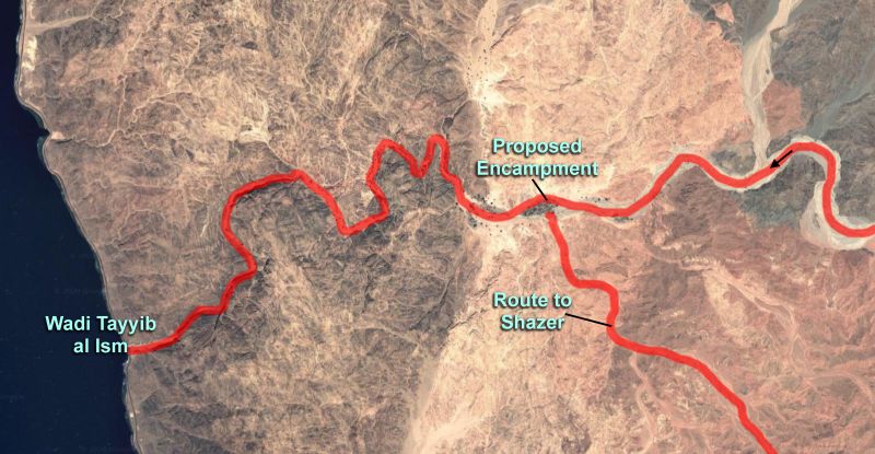
Note that in going to Shazer, they again traveled “into the wilderness” and traveled for four days to reach their next destination. This surely does not mean a total trip of four days, or total travel time of four days in the wilderness since Jerusalem, but four days for that leg. They departed into the wilderness as they left Jerusalem and then came to the borders of the Red Sea. Then they “traveled in the wilderness in the borders which are nearer the Red Sea; and he did travel in the wilderness with his family…. And it came to pass that when he had traveled three days in the wilderness, he pitched his tent in a valley by the side of a river of water” (1 Nephi 2:5,6).
As with the four days’ travel in the wilderness to Shazer, Nephi’s journey of three days to the River Laman and the Valley of Lemuel reads most naturally if taken as three days for that leg, the leg that began when they reached the Red Sea.
Reading it as three days total to the River Laman requires traveling impossibly fast. For our critics, it makes Joseph Smith a fool who could not make sense of distances on a map, in spite of being the resourceful plagiarizer who allegedly used rare high-end maps of the Arabian Peninsula to come up with intricate details like the place name Nahom from the tiny site of Nehhem in Yemen and or who could see a squiggle or two for a wadi or perhaps the words “Felix Arabia” to inspire a proposal for the lush, green site of Bountiful, nearly due east of Nahom, that would pan out almost miraculously over a century later as skeptics declared that no such place could exist in Arabia.
So what does one do when a text seems ambiguous, with one reading leading to interesting “enhancements” such as surprising fits with geographical or archaeological data, better correlation with later portions of the text, or overall added explanatory power once that reading is applied, while the other reading leads to an obvious fatal flaw that leaves the text hopelessly unrealistic or even impossible? Two choices, one that adds light and one that turns the light off — which one makes more sense?
This kind of scenario happens many times in various fields when there is uncertainty or ambiguity in how something might be understood. It can happen in evaluating scientific data or historical events, in weighing evidence and statements in jury trials, in translating a passage from a foreign language, or in reading poetry and deciding which of several possible meanings a poet have intended for an ambiguous word. If a seemingly plausible first interpretation leads to dead ends or ridiculous results, while a reasonable second reading opens up new windows of understanding as the result better fits with other data or provides explanatory power that helps things make more sense, then that second reading should be entertained even if the reader would be happy with the dead end from the first reading. The apparent new windows of understanding should not be closed, but at least entertained long enough to see if the path opened up leads somewhere meaningful. This is reading a text with generosity, or “giving the text (or evidence) a chance.” Of course, for purely polemical purposes, one can force any reading one wants onto a text one dislikes or onto the words of an opponent and declare victory, but this is not a path to understanding.
But What About the Header to 1 Nephi? Nephi’s Use of Exodus Themes
Dan Vogel recently made an interesting observation in a comment to a previous post of mine, “Three Days to the Valley of Lemuel — But From Where?” He argues that there is no ambiguity in the passage about the three-day journey and insists there is only one reading, based on Nephi’s header to the book of First Nephi. Vogel writes:
Nephi wasn’t ambiguous in his superscription: “The Lord warns Lehi to depart out of the land of Jerusalem. … He taketh three days’ journey into the wilderness with his family.” The late Bill Hamblin recognized this was a problem.
The point of the post that received Dan’s comment was to show that in light of the rhetorical or poetic tools Nephi applied, there really should be no ambiguity in the meaning of the three-days’ journey in 1 Nephi 2, for Nephi is clearly referring to three days since the Red Sea, not three days since Jerusalem. That may be even more clear when we consider, as discussed above, his next leg of wilderness travel requiring four days (obviously four days more, not in total) to Shazer. But Vogel makes a point that needs consideration: what does Nephi mean when he speaks of a “three days’ journey into the wilderness” in the header for First Nephi? It definitely sounds like the only travel mentioned between Jerusalem and their camp at the side of the River of Laman. Here’s the header:
An account of Lehi and his wife Sariah and his four sons, being called, (beginning at the eldest) Laman, Lemuel, Sam, and Nephi. The Lord warns Lehi to depart out of the land of Jerusalem, because he prophesieth unto the people concerning their iniquity and they seek to destroy his life. He taketh three days’ journey into the wilderness with his family. Nephi taketh his brethren and returneth to the land of Jerusalem after the record of the Jews. The account of their sufferings. They take the daughters of Ishmael to wife. They take their families and depart into the wilderness. Their sufferings and afflictions in the wilderness. The course of their travels. They come to the large waters. Nephi’s brethren rebel against him. He confoundeth them, and buildeth a ship. They call the name of the place Bountiful. They cross the large waters into the promised land, and so forth. This is according to the account of Nephi; or in other words, I, Nephi, wrote this record.
In this telegraphic summary, the only time of travel mentioned is the three days in the wilderness. Not the four days to Shazer, or the many days or many years (1 Nephi 17:4) of the rest of the journey. So does this necessarily refer to the entire trip from Jerusalem to the River of Laman, or is he highlighting the final three-day leg of that trip for some reason? Is there any explanatory power, any new meaningful insights, if we read the three-days’ journey in the header as a reference to the leg of their journey that began in the borders near the Red Sea? Why would Nephi even bother elevating that little detail, a three-day journey, to be included in his brief summary?
To understand what Nephi likely intended, we should consider Nephi’s agenda. He’s not just telling us random tidbits about a trip to escape Jerusalem. He’s describing an Exodus-like trek to a new Promised Land, led by a Moses-like prophet. Allusions to the Exodus play an important and clearly deliberate role in Nephi’s writings. See Terrence L. Szink, “Nephi and the Exodus,” in Rediscovering the Book of Mormon: Insights You May Have Missed Before, ed. John L. Sorenson and Melvin J. Thorne (Salt Lake City, UT: Deseret Book, 1991), 50–51; Kent S. Brown, “The Exodus Pattern in the Book of Mormon,” in From Jerusalem to Zarahemla: Literary and Historical Studies of the Book of Mormon (Provo, UT: Religious Studies Center, Brigham Young University, 1998), 75–98; John W. Welch and Greg Welch, “1 Nephi and Exodus,” Foundation for Ancient Research and Mormon Studies, 1999; and “Book of Mormon Evidence: Exodus and Nephi’s Wilderness Journey,” Evidence Central, Aug. 15, 2022.
Given Nephi’s many efforts to draw attention to parallels with the Israelite Exodus, the three days’ journey portion of the trip is a natural one to highlight. Recall that once Moses crossed the Red Sea, he led the Israelites into the wilderness for three days without water, and then water was provided with a miracle (Exodus 15: 22-25). [This paragraph was modified slightly on Dec. 26, 2023 for clarity, and the short paragraph after it was added.] The wording of Exodus 15:22 echoes Nephi’s account with a departure from the Red Sea (the water comes immediately after): “So Moses brought Israel from the Red sea, and they went out into the wilderness of Shur; and they went three days in the wilderness, and found no water.” Then they came to Marah, apparently still in the wilderness of Shur, but “could not drink of the waters of Marah, for they were bitter” (v. 23), but the Lord guided Moses to cast a particular tree into the water, miraculously making the water sweet (v. 25). In Nephi’s account, after they reach the borders of the Red Sea, then they travel three days in the wilderness, and reach a surprising river of water. It’s a reasonable parallel. Reach the Red Sea, travel three days in an arid wilderness, and then find miraculous water. (The parallel works best if the arrival at Marah occurs later on the third day, or if Nephi could plausibly have read it that way.) In 1 Nephi 2:5-6, just as Moses brought Israel along on this journey, so Nephi is bringing his family of Israelites. A desire to echo the phrase “So Moses brought Israel from the Red sea” of Exodus 15:22 may explain why Nephi rather redundantly restates who is with him as the three-day journey begins: “he did travel in the wilderness with his family, which consisted of my mother, Sariah, and my elder brothers, who were Laman, Lemuel, and Sam” (1 Nephi 2:5). If Nephi’s reference to a three-day journey in that passage makes the most sense as a parallel to the Exodus based on three days travel from the Red Sea to a miraculous fresh water source, then his reference to that same journey in the header must be understood as an effort to emphasize the Exodus themes associated with that leg of the journey rather than new information that three days refers to the entire journey from Jerusalem to the River Laman (or to Bountiful, for that matter).
On the other hand, or in addition, the reference to a journey of three days also reflects the request Moses made of Pharaoh to depart from their abode and travel three days in the wilderness to offer sacrifices (Exodus 3:18; 5:3; and 8:27). Indeed, once Lehi completes the three-day journey and arrives at the Valley of Lemuel, he offers sacrifices of gratitude to God. This parallel to the Exodus account may also have been intended by Nephi. Moses’s requests were denied, so it may be that Nephi chose to emphasize the three-day journey that was completed, the one from the Red Sea, while also echoing the aspect of sacrifice in the original requests Moses made.
There would be less potential ambiguity about the starting point of the three-day journey if Nephi had clarified that the wilderness (or portion of the wilderness) of the three-day journey was the one he had just mentioned in the previous verse, the wilderness near the Red Sea, but it’s still the most natural reading of the passage without such redundancy. The reference to “three days” in the heading for 1 Nephi refers to this highly symbolic and Exodus-like aspect of a much longer journey. It fits perfectly with Nephi’s agenda of drawing connections to the Exodus, makes sense grammatically, and has the bonus of nicely fitting what we now know of the long-undocumented geography of the Arabian Peninsula: that there is a surprising source of flowing fresh water within a three-day journey (by camel, of course) from the “borders of the Red Sea” near or “nearer’ the shore that Nephi would first encounter at the north end of the Red Sea. The Exodus parallel and the fit to real geography weighs heavily in favor of the most natural interpretation of Nephi’s words, and weighs against the alternate reading favored by those who prefer a non-miraculous, naturalistic origin of the book. That naturalistic reading with Joseph as the clueless author describing an impossibly fast journey does not lead to a unity of evidence or new windows of insight into Book of Mormon origins, and fails to explain the gems of the Arabian Peninsula such as the River Laman, the plausible location of Nahom and its relationship to ancient Nihm/Nehem tribal lands, the location of Shazer, or the miracle of at least one solid candidate for Bountiful nearly due east of Nahom. But great added insight and explanatory power comes when we accept the three day journey as one that began at the Red Sea.
I think the natural reading is far superior to the naturalistic one.


There is only one wilderness, which starts when Lehi left his house in Jerusalem. That is the natural reading of the text. The text becomes ambiguous because you have imposed an artificial reading of traveling in two wildernesses as an apologetic response to a problem in the text. Your attempt to dismiss the clear statement in the heading is tortured to say the least. You should know that Tayyib al-Ism isn’t a three day journey from the top of the Gulf of Aqaba. Potter didn’t measure the distance from Aqaba city but from port Aqaba about 16 miles down the coast. So, rather than 74 miles everyone likes to claim, it is actually 88 miles from the northern tip of Aqaba. Also, in moving Lehi’s campsite out of the canyon to the oasis and declaring the entire valley in which the wadi is situated creates a problem Aston didn’t address, namely how the valley can be described as being near the “mouth” of the river. Another problem is that the river flowing past the oasis, where Aston now situates Lehi’s camp, disappears for most of the year.
Dan, most of your comment doesn’t warrant any response because Jeff has well and truly covered it. But a couple of FACTUAL matters need clearing up:
Where did you get the information telling us the exact part of “top of the Gulf of Aqaba” the Lehites departed from to the Valley? How do you know it was Aqaba CITY? Or Aqaba port (which, by the way, is much less than “16 miles” from the town)? Perhaps Eilat?
Your sentence, “Also, in moving Lehi’s campsite out of the canyon to the oasis and declaring the entire valley in which the wadi is situated creates a problem Aston didn’t address, namely how the valley can be described as being near the “mouth” of the river.” is totally incoherent. I did no such thing, by the way. Talk about “tortured….” Can you re-state it so that we know what you are trying to say?
Lastly, you are factually wrong in stating that the river flowing through the valley “disappears for most of the year.” Your source for that gem? The current stream (that sometimes still becomes a fully-fledged river and even a flood that sweeps mature palm trees away if you do some research) runs down to the Red Sea ALL the year round; as have others, I have seen it running in multiple different months, including IN and JUST AFTER the “dry season.” If the Valley had not just been closed for NEOM development I’d suggest you get out of that comfortable armchair and buy a ticket to see for yourself.
Warren, thanks for responding and asking for clarification. First, I don’t think the BofM says the three-day journey starts from the top of Aqaba. So I don’t have to say where they started from. Nevertheless, many of the LDS interpreters, including you, have represented that the three-days begins at the northern tip of Aqaba. Often the claim is that Lehi travel 74 miles from Aqaba, so I measured the distance from Aqaba city center, which was near the ancient port and located at the northern tip of Aqaba. The 16 miles is the distance from Aqaba city center to Aqaba port near the Jordan/Saudi Arabia border using Goggle maps. You have name Eilat, which is farther.
I think Potter confused subsequent interpreters, including you, and that everyone should know that the 74 miles is calculated 16 miles down the coast from where they have assumed Potter started. At the very least, Potter should justify why he began measuring the distance where he did. Such transparency can then be used to more accurately assess the plausibility of the Tayyib al-Ism proposal.
What I was trying to say about your moving the campsite out of the canyon into the larger and longer valley is that your identification of the valley of Lemuel no longer fits the BofM’s description of a valley located near the mouth of the river, which seems to imply that the river was longer than the valley. Prior to this, many interpreters including you in your 2015 book (where you included an illustration by Chadwick) located Lehi’s campsite near the coastal entrance of Wadi Tayyib al-Ism. In your 2019 article, you skipped over problems caused by moving the campsite to the oasis. For one thing, the perennial stream no longer flows past Lehi’s tent, and there is no mentioned of a disappearing and reappearing stream. This forces you to give eisegetic interpretations for the various passages mentioning the river, one for Lehi pitching his tent in a valley next to a river, another for the valley being near the mouth of the river, and yet another for the river “continually running into the fountain” of the Red Sea. Sounds like a lot of manipulation of the text to me.
On the last item, I think you are confused. I said the river that runs past the oasis disappears most of the year. I’m well aware that the gravity-fed spring runs year around, even if it doesn’t reach the Red Sea except on rare occasions. You shouldn’t use phrases like “runs down to the Red Sea” if you want to be transparent. Like Potter’s “from Aqaba,” when something like “from modern Aqaba’s southern city limits” would have been more accurate.
Finally, you (and Potter) like to proclaim your only credentials on this subject. I don’t know how you think that’s a disqualification for anything I have written, or that my going there in person will help you.
What a gem to have visit from Dan Vogel!
Is the thread linked below, cultural Mormon Warren Aston ran away defeated. Let see if he runs away again.
https://www.arisefromthedust.com/nahom-nhm-only-a-tribe-not-a-place/#comments
About the argument over “three days’ journey into the wilderness:”
To me, it is very likely that the heading (headnote or colophon) for the First Book of Nephi was written by Mormon (not Nephi). Mormon used headnotes to briefly describe the content, source, and authorship of each major section of the gold plates that he assembled into the historical record of his people. In that headnote, Mormon testified that the author of the First Book of Nephi was Nephi himself. When Nephi began those writings on the “small plates of Nephi,” he inscribed his own headnote (or colophon) in the first three verses before he started to record his family’s history in verse four (1 Nephi 1:1-4).
When Mormon’s heading says that Lehi took “three days’ journey into the wilderness with his family,” he got that idea from reading Nephi’s original record about a thousand years after Lehi’s trek (1 Nephi Preface:Heading). By contrast, Nephi’s contemporary report stated that they arrived at the Red Sea, then “when [Lehi] had traveled three days in the wilderness, he pitched his tent in a valley by the side of a river of water” (1 Nephi 2:5-6). Nephi said, “I know that the record which I make is true; and I make it with mine own hand; and I make it according to my knowledge” (1 Nephi 1:3).
It is instructive to view Tayyib al-Ism in Saudi Arabia with Google Maps. It is the only place with a “continually running river [or stream] which empties into the Red Sea” (1 Nephi 2:9). It is a popular tourist attraction for the people of Saudi Arabia, so look at the photos and videos they post there on Google Maps. Switch to the satellite layer view, which lets you zoom in to see individual bushes, palm trees, and tire tracks in the sand! Then zoom out to see the rugged desert mountains and their wadis (a wadi is a desert watercourse that is dry except during rare rainstorms). Drag the image downward until you can see the top (northern end) of the Gulf of Aqaba.
Now imagine you are trekking with Lehi’s family and his pack camels as “he traveled in the wilderness in the borders which are nearer the Red Sea” (1 Nephi 2:5). Zoom in to see the seashore as you drag the map upwards to follow Lehi’s trek along the seashore toward the south. You will notice that the sandy seashore disappears where the rugged mountains suddenly extend into the sea. Lehi has no choice but to turn east and head inland, hoping to find a way around the mountain that blocked his seaside trek. Now zoom out. Use your imagination to continue the trek up into mountain wadis to find a way that will lead back west to the shores of the Red Sea. Notice that the major wadi trails suddenly make a turn to the west and lead directly to Tayyib al-Ism! It was a perfect place to camp and rest “in a valley by the side of a river of water” (1 Nephi 2:6). Then imagine the curious boys hiking down the deep winding canyon to see where the flowing water went. Through their report, Lehi learned “that the waters of the river emptied into the fountain of the Red Sea,” just 2 miles west of their campsite (1 Nephi 2:9).
About the argument over “three days’ journey into the wilderness:”
To me, it is very likely that the heading (headnote or colophon) for the First Book of Nephi was written by Mormon (not Nephi). Mormon used headnotes to briefly describe the content, source, and authorship of each major section of the gold plates that he assembled into the historical record of his people. In that headnote, Mormon testified that the author of the First Book of Nephi was Nephi himself. When Nephi began those writings on the “small plates of Nephi,” he inscribed his own headnote (or colophon) in the first three verses before he started to record his family’s history in verse four (1 Nephi 1:1-4).
When Mormon’s heading says that Lehi took “three days’ journey into the wilderness with his family,” he got that idea from reading Nephi’s original record about a thousand years after Lehi’s trek (1 Nephi Preface:Heading). By contrast, Nephi’s contemporary report stated that they arrived at the Red Sea, then “when [Lehi] had traveled three days in the wilderness, he pitched his tent in a valley by the side of a river of water” (1 Nephi 2:5-6). Nephi said, “I know that the record which I make is true; and I make it with mine own hand; and I make it according to my knowledge” (1 Nephi 1:3).
It is instructive to view Tayyib al-Ism in Saudi Arabia with Google Maps. It is the only place with a “continually running river [or stream] which empties into the Red Sea” (1 Nephi 2:9). It is a popular tourist attraction for the people of Saudi Arabia, so look at the photos and videos they post there on Google Maps. Switch to the satellite layer view, which lets you zoom in to see individual bushes, palm trees, and tire tracks in the sand! Then zoom out to see the rugged desert mountains and their wadis (a wadi is a desert watercourse that is dry except during rare rainstorms). Drag the image downward until you can see the top (northern end) of the Gulf of Aqaba.
Now imagine you are trekking with Lehi’s family and his pack camels as “he traveled in the wilderness in the borders which are nearer the Red Sea” (1 Nephi 2:5). Zoom in to see the seashore as you drag the map upwards to follow Lehi’s trek along the seashore toward the south. You will notice that the sandy seashore disappears where the rugged mountains suddenly extend into the sea. Lehi has no choice but to turn east and head inland, hoping to find a way around the mountain that blocked his seaside trek.
Now zoom out. Use your imagination to continue the trek up into mountain wadis to find a way that will lead back west to the shores of the Red Sea. Notice that the major wadi trails suddenly make a turn to the west and lead directly to Tayyib al-Ism! It was a perfect place to camp and rest “in a valley by the side of a river of water” (1 Nephi 2:6). Then imagine the curious boys hiking down the deep winding canyon to see where the flowing water went. Through their report, Lehi learned “that the waters of the river emptied into the fountain of the Red Sea,” just 2 miles west of their campsite (1 Nephi 2:9).
In his criticism of Warren Aston, Dan Vogel misquoted the Book of Mormon. 1 Nephi 2:8 does not say “a valley located near the mouth of the river,” Instead it says, “the valley was in the borders near the mouth thereof.” Vogel left out the “in the borders” part of the description.
1 Nephi 2:8 reads: “And it came to pass that he called the name of the river, Laman, and it emptied into the Red Sea; and the valley was in the borders near the mouth thereof.”
The oasis valley of Tayyib al-Ism precisely fits the 1 Nephi 2:8 description. It is a valley in the borders of the Red Sea, just 2 miles from the mouth of its perennial flow of water into the Red Sea.
Wanless Southwick: Of course I wasn’t quoting or misquoting the 1 Nephi 2:8, but paraphrasing. You are merely quibbling and not raising any meaningful objection. The passage says the valley was near the mouth of the river (meaning near the beach) as opposed to not being near the mouth. So your objection attempts to distract from my point, which is: as originally argued, the canyon was the valley of Lemuel, but once Aston moved Lehi’s camp up into the larger valley, which goes on for many miles, it no longer fit the description.
This is but one problem with Tayyib al-Ism. So it is an exaggeration to say it “precisely fits” the BofM’s description. It requires adjustments to its present condition and some manipulation of the text. Your last two sentences have a few distortions.
The oasis is about 4 miles from the mouth of Wadi Tayyib al-Ism, and about a half mile from the source of the spring in the canyon. Hence, water flows by the oasis only sporadically during the rainy season.
The borders “nearer” the Red Sea is along the coast, not in the mountains. Potter and Wellington’s argument linking borders and mountains linguistically has been refuted by Chadwick. So saying the oasis (about 4 miles inland) is in a valley in the borders is a stretch.
The stream at Tayibb al-Ism doesn’t empty/flow/run into the Red Sea year-round, only on rare occasions, and certainly not past the oasis. You make it sound so simple, but it’s not.
Wanless Southwick: Mormon did not write the heading to First Nephi. It clearly states at the end: “I, Nephi, wrote this record.” It doesn’t matter who wrote it; the meaning is still the same. It clearly states that Lehi traveled three days in the wilderness, not a day longer. The wilderness didn’t begin at the Red Sea. The river should be found near the northern end of the Gulf of Aqaba.
Tayyib al-Ism doesn’t have a “continually running river [or stream] which empties into the Red Sea” (1 Nephi 2:9). Some apologists try to separate the “continually running” and the sometimes “empties into the Red Sea.” But you can’t put them together without being disingenuous.
“Lehi has no choice but to turn east and head inland, hoping to find a way around the mountain that blocked his seaside trek.” Yet the text says nothing about this. Rather, it implies the river and valley were discovered from the coast, not a 30-mile inland trek.
“It was a perfect place to camp and rest “in a valley by the side of a river of water” (1 Nephi 2:6).” So if there is a river running by the oasis and it’s the rainy season, shouldn’t there be water in the other wadis in the region? Wouldn’t this make passage in the mountainous wadis leading to Tayyib al-Ism difficult, if not dangerous? Wouldn’t it make the three-day trip even less likely? These are just a few problems Aston needs to answer.
The following seems to have gotten lost:
Jeff, the parallels between the desert wanderings of the Israelites and Lehites have long been noted as a probable source for Joseph Smith. However, that doesn’t explain anything about the heading to First Nephi. You don’t even know if the “three days” was intended as a parallel, whether by JS or Nephi. I don’t think your example from Exodus 15:22 is striking. They found no water. How is that a parallel? Most have used Exodus 3:18, 5:3, or 8:27, which mentions the Israelites travelling three days and offering sacrifice. In First Nephi, Lehi travels three days and then offers sacrifice (1 Nephi 2:6-7). However, the heading plainly states that the trip in the wilderness took three days. There is no ambiguity or equivocation. Since it was written first and read first, it should resolve any misreading (between the lines) of 2:4-6. You beg the question by assuming your specialized reading of the text is what Nephi intended, and then try to interpret the heading using that assumption. Whereas the heading’s less ambiguous wording should be used to resolve a possible misreading. Actually, the text is only ambiguous because apologists have created it by attempting to insert a tortured reading. To get the reading you need, it should have said: “when he had traveled three days in the border near the Red Sea.” Otherwise, there is no indication that the text refers only to the wilderness. Note that after 2:5 says Lehi traveled in the “wilderness in the borders which are nearer the Red Sea,” it says “he did travel in the wilderness with his family.” Now, does it mean his family was only with him in the border wilderness? No, of course not, because there is only one wilderness. Then, in the next verse, it says Lehi had traveled three days in the wilderness. Why the confusion? The apologetic reading makes no sense to me.
Dan said, “the heading plainly states that the trip in the wilderness took three days.”
The complete trip in the wilderness took eight years, not just the three day of one particular leg. Why not mention the length of the whole trip in the header? What’s so special about the three days? The point is that something is special about a three-day leg that was an important part of the overall summary. Why? Nephi’s authorial agenda must be considered. Nephi uses the word “wilderness” for all their travels.
Which leg of the journey was the three-day leg? The leg AFTER Lehi “came down by the borders near the shore of the Red Sea” (1 Nephi 2:5). It is after this that we learn about further travel in a different zone, no longer the borders that are just “near the shore of the Red Sea,” but but border that are now even nearer, for then Nephi writes, “and he traveled in the wilderness in the borders which are nearer the Red Sea.” How long did he pursue this leg of the journey “nearer” the Red Sea? Three days, as the next verse tells us: “And it came to pass that when he had traveled three days in the wilderness, he pitched his tent in a valley by the side of a river of water” (1 Nephi 2:6).
My proposal is that Nephi, wising to stress Exodus-like aspects of his journey, used language and symbols reflecting the account of Moses. Moses led his people in the wilderness. He brought them to the Red Sea. Then they traveled for three days. No water at first, but then came the nearby waters of Marah, provided in drinkable form by a miracle. Similar patterns happened in Nephi’s account. The three day journey, one particular leg from the Red Sea to a miraculous place with fresh water, makes an apparent parallel that could have impressed Nephi. I propose that’s why he mentioned the duration of that leg in his header. Accepting that possibility opens us up to stronger explanations about Nephi’s authorial intent, about the geography of the real places he encountered, and the terrain he encountered. Refusing to accept that leaves us with Joseph as an ignoramus who thought a large distance could be traversed in three days with children along and apparently on foot (the assumption of camels requires mere application of the basic realities of travel in Lehi’s day, but the text does not mention them explicitly — there was no need to, at least not for Nephi).
The reader here can choose between two lenses when considering the three-day journey. One lens blurs everything and makes it all look like nonsense. The other lens bring numerous details into focus, such that examining intricate details on Google Earth or information from explorers who visited specific sites can reveal details that add depth and understanding to the text. Such beauty and clarification would be impossible with any lens or any assumptions about possibly ambiguous passages of they were fabricated nonsense. Giving Nephi a miraculous helicopter for a swift three-day journey to anywhere in the Arabian Peninsula would not add one ounce of beauty or explanatory power or insight if there were no candidates at all for a River Laman, a place called Nahom, or a site that could be called Bountiful. Look at the marvelous details that demand attention and gratitude — don’t try to unfocus you view with a lens designed to blur and hide detail.
And yet again they had no retort to Dan Vogel.
Sorry for my late reply. Rough few weeks in terms of time. But thanks for the thoughts several of you have shared. Here are responses to a few questions raised:
(1) A river too far? Dan raises an argument I haven’t heard before. He argues that “Potter didn’t measure the distance from Aqaba city but from port Aqaba about 16 miles down the coast. So, rather than 74 miles everyone likes to claim, it is actually 88 miles from the northern tip of Aqaba.” Dan, where did you get this idea? I have Potter’s book, Lehi in the Wilderness, before me as I write, and your claim doesn’t fit his report. I’m looking at the details he gives on pages 25-28. He speaks of the last caravan town that Lehi might have seen, Ezion-geber near modern Aqaba (p. 25), not some remote port. An initial approach near the Eilat/Aqaba area is the most reasonable one for Lehi’s journey. While the exact location of Ezion-geber may be unclear, Britannica says archaeological evidence points to a location at Aqaba (see “Ezion-geber“). In any case, it’s clear that Potter is starting near Aqaba. He speaks then of driving south and states that they went 25 miles to Haql (p. 25). There is a slight problem here, but it’s the opposite of the problem you see. If you use Google Earth to measure the distance from a spot just north of Aqaba and then south to Haql, the distance is more like 18 or 19 miles, not 25. Perhaps Potter was actually measuring from Eilat? I’ll see if I can learn more about this. But he’s clearly NOT starting from a remote port.
If he mentioned a Port Aqaba in some talk or other paper, I could see how that could justifiably inspire your concern. But if that’s the case, please note that there are at least 3 regions along the Red Sea that can be called Port Aqaba or Aqaba Port, per Google Maps. One is next to Eilat, just west of Aqaba, and then there are two further south on the Red Sea. See Google Maps at https://www.google.com/maps/search/port+aqaba/@29.4720703,34.8941159,11.36z?entry=ttu. If Potter did once refer to travels that began at Port Aqaba, I think it would have to be the one near Eilat, and perhaps that could help explain why his distance to Haql is reported as 25 miles instead of 18 or 19 miles. But based on his book, it seems that he began at Aqaba.
So how far is it from Aqaba to Wadi Tayyib al Ism, the fabulous candidate for the River Laman and the Valley of Lemuel? A beeline from Aqaba to Wadi Tayyib Al Ism is about 66 miles based on what I see on Google Earth, though Potter reports it as 62 miles on p. 25 of his book. But when I use Google Earth’s “path or polygon” tool and draw lines following what I take to be Potter’s path from Aqaba,, south to Haql, then six miles east through a valley in the mountains, and then south to a long wadi that leads directly into Wadi Tayyib al Ism, the length of the series of lines along the slightly crooked path is 75 to 76 miles, starting slightly north of Aqaba. If I sum up the length of the segments Potter reports (25 miles to Haql, 15 south of Haql, 6 miles east, 3 miles south, and then 22 miles into Wadi Tayyib al Ism), that gives 71 miles — but I think the 25 miles to Haql is too long by about seven miles and the 15 miles south of Haql to an eastward turn into the mountain seems too short by roughly 10 miles. After some possible corrections, Potter’s account still makes sense. They were able to pursue a reasonable path based on Nephi’s directions that led them to a beautiful and still miraculous place of water and shelter (miraculous given how loudly the experts proclaimed that no such place existed or could exist) that would have been within a feasible three-day journey from a spot near Aqaba, leading a gathering of Israelites on a miraculous journey from the Red Sea to a source of water, just as Moses did.
Note that Wadi Tayyib al Ism is not just an ideal candidate for a continually flowing stream (‘river”) that flows into the fountain of the Red Sea in the welcome shade and shelter of an impressive valley, but is also an ideal candidate for starting point for a wonderfully feasible south-southeast journey to Shazer that can literally begin just as Nephi reports: after packing up their gear, they walk across the river and begin going south-southeast. There is a wadi directly across the River Laman candidate from the logical encampment site on the north of the stream, and an opening in the canyon wall there that one can take to reach the place Shazer (or the ideal candidate as proposed by Aston). That’s part of the explanatory power that is gained by recognizing Wadi Tayyib al Ism as a candidate that follows from seeing the borders near the Red Sea as the starting place for the symbolic three-day trek imitating Moses in leading Israel past the Red Sea to a miraculous source of water.
More to come….
Continuing my response:
(2) A mouth too far? Dan offers another challenge: “Also, in moving Lehi’s campsite out of the canyon to the oasis and declaring the entire valley in which the wadi is situated creates a problem Aston didn’t address, namely how the valley can be described as being near the ‘mouth’ of the river.” 1 Nephi 2:8 mentions the river and a valley that “was in the borders near the mouth thereof.” A mouth of the river appears to be needed needed when Nephi speaks of the stream entering the Red Sea, or rather, the “fountain” of the Red Sea: “And when my father saw that the waters of the river emptied into the fountain of the Red Sea, he spake unto Laman, saying: O that thou mightest be like unto this river, continually running into the fountain of all righteousness!” (1 Nephi 2:9). These are observations that make the most sense if they were spoken in broad daylight, perhaps the day after a nighttime arrival.
As George Potter has pointed out, the three-day journey of around 70-75 miles would consume three full days of travel, so it was probably dark when they finally settled down. From where they probably camped, the nice encampment site with palm trees, they were still over a mile away from the Red Sea. Nephi’s use of “and when my father saw” in 1 Nephi 2:9 suggests a lapse in time following their arrival, consistent with further exploration sometime the next day as opposed to camping right at the shore of the Red Sea on the night they arrived. But Lehi could have chosen to camp anywhere in the wadi and later wandered down with his family to where the stream entered into the “fountain” of the Red Sea, and then launched into his discourse. His discourse makes perfect sense if the imposing valley and the stream’s entry into the “fountain” of the Red Sea were both within view of where Lehi stood, a condition that is easily met. That place need not be at their encampment.
Dan may also have objections in mind that others have made regarding the mouth of the River Laman. Please see a discussion of this issue in my article, “Joseph and the Amazing Technicolor Dream Map: Part 1 of 2,” Interpreter: A Journal of Latter-day Saint Faith and Scholarship 19 (2016): 153-239, especially at pp. 184-5 and 209-10. Some have argued that the Red Sea is not a fountain, and others have argued that there is no mouth to the proposed River Laman because the stream descends into gravel about half-a-mile away from the Red Sea. While it may be that the stream was stronger anciently and could have flowed directly into the Red Sea at the shoreline, there is another possibility. Nephi, with his Ancient Near Eastern perspective, could well have understood the stream to be entering the body of subterranean waters that feed the Red Sea, or in other words, literally entering the “fountain of the Red Sea.” The way the stream enters those subterranean waters near the shore could be what inspired Nephi’s seemingly unusual use of the word “fountain” here. Again, minute details in Nephi’s record align nicely with physical reality when viewed carefully — or when the text is “tortured,” as Dan prefers to put it.
Whoa, Dan, I’m still confused about your argument. Potter clearly refers to modern Aqaba in discussing his trip. He did not start at a port remote from the actual city. But are you arguing that Nephi must have been 16 miles away from the Red Sea when he began his three-day journey? Where do you get that notion?
For anyone unsure about where Aqaba is, I’ve been there and it is definitely a city on the sea. You can see that downtown Aqaba is right on the coast in Google Maps. But of course, Nephi doesn’t tell us exactly where he started, apart from referring to “borders” (or mountains, as Potter plausibly argues) near the Red Sea and nearer the Red Sea. Staying overnight very close to the Red Sea before beginning the three-day trek cold plausibly have occurred near Aqaba. Not 16 miles away.
Ah, I see a problem. When I cited the story at the waters or Marah from Exodus 15:22-25, I only explicitly quoted the first verse of that package, where they had not yet found water as they came to the wilderness of Shur. It’s in the next three verses where the miraculous water is provided at Marah. I quoted more of that passage in my slightly revised post and also noted that the parallel works best if they also reached Marah on the third day, or at least if someone like Nephi might read it that way. I also note that the issue of a sacrifice after a three-day journey is also echoed in Nephi’s account as Lehi offers sacrifice in the Valley of Lemuel.
Again, the distance from the beginning of the Red Sea (there were explicitly “near the shore” of the Red Sea before the three-day journey began) can be taken to begin near modern-day Aqaba. Potter drove from Aqaba to Haql and then further south, then eastward for a while and south again, ultimately reaching the candidate for the Valley of Lemuel before reaching the 75 mile limit he had set (I believe he has reported it to be 74 miles per his odometer, as reported in his videos). There is no serious problem here.
Somebody wake up Dan.
This exchange is fascinating… the excruciating interpretation of details. I’d think it really shouldn’t be so difficult to establish distances and routes, but I’m just a layman.
Why mention “three days”? Clearly, Nephi was talking about the first long-term campsite, from which he and his brothers returned to Jerusalem. Your response in this matter fails.
The three days don’t refer to traveling in the borders “nearer” the Red Sea. This also fails because it contradicts the preface, is an eisegetic reading of the text, and a distinction the text doesn’t make (there is only one border). Lehi comes down near the border and then travels in that border. The heading doesn’t say they traveled three days in the border. It’s three days in the wilderness, part of which was in the border. You also inconsistently argue with Potter that border means mountains, which it doesn’t. The borders (mountains) nearer the Red Sea are 40 miles south of Aqaba. So, how does that equate to a three-day journey in the borders?
My proposal is that JS made the mistake. Not all maps have miles indicated, and he may have been using one map for Bible lands and another for Arabia. Three days is nothing when you consider all the improbabilities in the story. Despite my pointing out that most other researchers point to Moses’ traveling three days and offering sacrifice, you still want to go with the arbitrary three day trip to water, which shows the weakness of your parallelism.
Jeff, why don’t you measure the distances yourself? It seems everyone has relied on Potter’s numbers without fact checking. He says it’s 44 miles from Aqaba to where the mountains run into the Red Sea, preventing further travel down the coast and forcing Lehi to turn east into the mountains. This distance is actually 57 miles. Don’t get confused by his discussion of Halql. There are two ways to get to the back entrance of Tayyib al-Ism. Halql is not the one he uses. He turns east at the small promontory of Ras Suwayhil al Saghir. You will find that measuring from the Port of Aqaba (16 miles below Aqaba city center), you will get 44 miles. The other port you mention is in Israel, not Jordan.
I already figured it out that Potter didn’t begin at the top of the Gulf of Aqaba, despite everyone showing it on their maps (including Potter) while saying it was 74 miles, but Potter confirmed that he started at Port Aqaba (in Jordan) in a response to my interview with Stephen Murphy. Potter continues to give out this false information in a presentation he recently gave at the BofM conference (on YouTube).
Your problem is that you are using the measuring tool. Use Google Maps from Aqaba to Ras Suwayhil al Saghir, which brings you about 57 miles to the mountain obstruction. This is where they turn east into the mountains, following the wadis east and then south until they hit Wadi Tayyib al-Ism, then another 3 miles west to the oasis. If you think Lehi camped near the mouth of the canyon, it’s another 3-4 miles. If you use the measuring tool and follow the wadis in detail, as I did, you will get about 28-30 miles depending on which wadi you go up from the Red Sea.
BTW, Potter didn’t follow Nephi’s directions. He first found what he believed was the valley of Lemuel and then made it fit Nephi’s description (not directions). Forget the two mountain ranges theory; it doesn’t work. I’m with Chadwick. Tayyid al-Ism doesn’t fit, and neither does any other wadi. How apologists can follow all these adjustments with a declaration that Tayyib al-Ism is a perfect fit is beyond me.
Also, forget your subterranean fountain theory as well. With that, you throw out Potter’s and Aston’s attempts to raise the sea and expand the spring’s flow, which are also dead ends. Your interpretation demonstrates your desperation and that you don’t have much confidence in Potter’s and Aston’s theories. Lehi’s dream shows what is meant by fountain. It was deep enough for people to drown. The river had a mouth, and the valley was near it.
My criticism about the valley being near the mouth of the river is that situating Lehi’s campsite at the oasis in the wider and 20-mile-long valley, rather than seeing the canyon as the valley of Lemuel, renders the BofM’s description meaningless. (BTW, the oasis is about 4 miles east of the Red Sea.)
BTW, there are many scriptural examples of what might be called a literary formula or rhetorical technique using “when he saw” (and its variations), which have nothing to do with a discovery or lapse of time.
As I revealed in my interview with Murphy, I think JS looked at a map that incorrectly portrayed the tip of Aqaba with what he might have interpreted as a river. Many early maps label this as the Gulf of Gold or something like it, because it was the location of the ancient port of Ezion-Geber, where Solomon imported gold from Opher. You can see this feature on many of the maps collected by James Gee for Nahom. Jeff actually mentioned this in his Interpreter article but didn’t make the connection.
Dan, can you point to a map that Joseph could have used? For your theory to hold water, it ought to be one of the maps that can also give the place Nehem/Nahom. Several such maps show the full Red Sea and the two forked ends of it, the Gulf of Suez and the Gulf of Aqaba. And it would need to be a map that Joseph theoretically could have had access to. So far it looks like no such map was within 100 or more miles of Joseph Smith, and there is absolutely no evidence that he used such a map.
I don’t see anything on the Nahom maps, as published by James Gee, that look like a river unless you are suggesting that Joseph mistook the Gulf of Aqaba on a low-resolution map for a river. But he didn’t come to such a “river” first. He first came near the shore of the Red Sea, and then after further traveling (three days, FYI), they found the valley and the river.
For measurements and further details, see my latest post on this topic: https://www.arisefromthedust.com/further-thoughts-on-nephis-three-day-journey-going-the-distance-with-google-earth/
On several related issues, including the potential use of maps by Joseph, see my “Joseph and the Amazing Technicolor Dream Map: Part 1 of 2” at https://journal.interpreterfoundation.org/joseph-and-the-amazing-technicolor-dream-map-part-1-of-2/ and Part 2 at https://journal.interpreterfoundation.org/joseph-and-the-amazing-technicolor-dream-map-part-2-of-2/.
Jeff, I don’t think JS got Nahom from a map any more than I think he got Moroni from looking at a map of the Cumora/Comoro Islands. Both parallels are coincidences aided by imaginative researchers. The feature I’m suggesting JS saw as the river Laman and valley of Lemuel is so common that there is no need to identify a specific map. Geography was taught in schools. There were several books on geography explicitly created for schools. Typically, the maps came in separate booklets, which are rare or lost today. It would be foolish to suggest that JS couldn’t have seen maps of the Holy Land or Arabia.
It appears you are having difficulty locating the feature I have referred to as the “Gulf of Gold,” which you mentioned as “Gold Haven” on page 263-64 of part 2 of your two-part article for Interpreter. https://journal.interpreterfoundation.org/joseph-and-the-amazing-technicolor-dream-map-part-2-of-2/
You reproduce the map as “Gulf of Aqaba detail on the 1794 D’Anville map of Arabia,” which is map 7 in James Gee’s article. If you look at the top of the Gulf of Aqaba, you will see that it forks. At the top of the western fork is Ailah, and at the top of the eastern fork is Aqaba. This feature was erroneous and later removed from the maps. It was called “Gold Haven” or the “Gulf of Gold” because it was where Solomon imported gold from Ophir. The western fork looks like a continuation of the gulf, whereas the eastern branch is in a valley, possibly mistaken by JS for a river that emptied into the fountain of the Red Sea.
You can see this feature on maps 3, 4, 5, 6, 7, 8, 9, and 10 in Gee’s article. Now that you know what I’m referring to, you can find it on many other maps not mentioned by Gee.
So you’re saying that naming the burial place of Ishmael as a place others called “Nahom” was a purely random act, and that it was just coincidence that there is an ancient NHM region that happens to be reachable by going south-southeast from the River Laman, and that it’s just a coincidence that going nearly due east from that NHM region can get you to an excellent candidate for Bountiful? The people who are implausibly arguing that Joseph got the idea for Nahom from Nehem on a rare map that was likely inaccessible to him and nowhere within 100+ miles of him are offering a far more plausible explanation than your approach of calling it all coincidence. Pure coincidence? NHM place names are rare in the Arab world, and to have one in just the right place for Nahom, and also the right time, with solid archaeological evidence from even before Lehi’s day demonstrating the prominent role of the Nihm tribe, and having a seemingly ideal candidate for Bountiful actually be nearly due east of that, calls for more reflection IMO than such reflexive dismissal.
BTW, if my analysis is correct that JS authored the “Lehi’s Travels” statement before Cowdery and three others left New York on their mission to the Lamanites in October 1830, then he certainly did have access to a detailed map of Arabia. This statement reads:
“The course that Lehi and his company traveled from Jerusalem to the place of their destination: They traveled nearly a south, southeast direction until they came to the nineteenth degree of north latitude; then, nearly east to the Sea of Arabia, then sailed in a southeast direction, and landed on the continent of South America, in Chili, thirty degrees south latitude.” Joseph Smith
“LEHI’S TRAVELS.–Revelation to Joseph the Seer,” in Franklin D. Richards and James A. Little, A Compendium of the Doctrines of the Gospel (2nd ed.; Salt Lake City: Deseret News Co., 1882), 289.
For my analysis, see https://www.youtube.com/watch?v=Fx2ijUSwuPk
Thanks, Dan, for raising an interesting point. I have three points to offer in response:
1. It’s fascinating if that statement really reflects Joseph’s view on where Lehi turned east, for it shows ignorance of the location of Nehem on rare maps of Arabia in Joseph’s day, where it is placed much further south. James Gee has published an article about the few rare maps from Europe made prior to 1839 that did show place names related to the Nihm tribe (see James Gee, “The Nahom Maps,” Journal of Book of Mormon Studies, vol. 17, no. 1, https://scholarsarchive.byu.edu/jbms/vol17/iss1/6/). The location of Nahom-related names on those maps appears to be near the 16th to 17th parallels, not the 19th parallel. Turning east at the 19th parallel would keep Lehi far to the north of the only plausible candidate region for Nahom, which corresponds well with modern Nihm tribal lands. You can see the Nihm territory on Google Earth if you search for Nihm, and it runs from about the 15th to 16th parallel, but might have included more lands to the north anciently, but not as far as the 19th parallel. So if Joseph made or endorsed that statement, he certainly did not have access to a map that inspired the use of “Nahom” to describe the place where Ishmael was buried and where the turn east was made.
It also suggests that Joseph or the author of the statement did not know where candidates for Bountiful were, for they are near the southern border of Oman with Yemen, while the 19th parallel runs close to the northern border of Oman with Yemen, not close to the Dhofar region.
Turning east at the 19th parallel would send Lehi and his family across the great Empty Quarter and to certain death. Turning east in the lands of the Nihm tribe, such as at Wadi Jawf, is about the only place where the eastward turn can miss the great desserts to the north and to the south, with a plausible but difficult passage across Yemen that could indeed allow a group to wander straight into Wadi Sayq and reach the primary candidate for Bountiful at Khor Kharfot. Whether it was Joseph or a later peer who wrote those words, there is no hint that anyone knew about Nehem on a map or a candidate for Bountiful on a map. This strengthens the case that Joseph did not rely in the rare and largely inaccessible (to him) rare maps that showed Nehem/Nehhm.
Given all that, it would be great if we could show that this statement really reflected Joseph’s guess about where the eastward turn was. It shows that he, or whoever authored it, didn’t even have Nahom on their radar, much less their map, for Nahom is not mentioned and there is no awareness of the location of Nehem on actual maps.
2. I must point out that even if we entirely accept your thoughts on this disputed document, the date of October 1830 is over a year after the translation of the Book of Mormon was completed and also well after the book had been published in March 1830. At best it indicates that by October 1830, Joseph or a colleague or a Book of Mormon enthusiast had access to a map or globe with enough detail to identify the 19th parallel north, That’s a very low bar for which almost any map showing Arabia will do. Such maps almost never showed Nehem or related names. But yes, the 19th parallel that seems like a reasonable guess based on what one might see on an ordinary low-resolution map showing the location of the Arabian Peninsula without details like the nearly uncrossable Empty Quarter.
3. However, there are good reasons to question the claim that Joseph wrote this or that the statement came from 1830. Here, for example, is footnote 11 in Paul R. Cheesman, “Lehi’s Journeys,” in First Nephi, The Doctrinal Foundation, ed. Monte S. Nyman and Charles D. Tate Jr. (Provo, UT: Religious Studies Center, Brigham Young University, 1988), 241–50, where he cites B. H. Roberts, New Witnesses for God (Salt Lake City: Deseret News Press, 1951), 3:501–3.
“In a compendium of doctrinal subjects published by the late Elders Franklin D. Richards and James A. Little, the following item appears: ‘Lehi’s travels.—Revelation to Joseph the seer: The course that Lehi and his company traveled from Jerusalem to the place of their destination: They traveled nearly a south, southeast direction until they came to the nineteenth degree of north latitude; then, nearly east of the Sea of Arabia, then sailed in a southeast direction, and landed on the continent of South America, in Chili, thirty degrees south latitude.’
“The only reason so far discovered for regarding the above as a revelation is that it is found written on a loose sheet of paper in the handwriting of Frederick G. Williams, for some years second counselor in the First Presidency of the Church in the Kirtland period of its history, and it follows the body of the revelation contained in Doctrine and Covenants, section vii., relating to John the beloved disciple, remaining on earth, until the glorious coming of Jesus to reign with his Saints. The handwriting is certified to be that of Frederick G. Williams, by his son Ezra G. Williams, of Ogden; and endorsed on the back of the sheet of paper containing the above passage and the revelation pertaining to John. The indorsement [sic] is dated April, the 11th, 1864. The revelation pertaining to John has this introductory line: ‘A Revelation Concerning John, the Beloved Disciple.’ But there is no heading to the passage relating to the passage about Lehi’s travels. The words ‘Lehi’s Travels,’ and the words ‘Revelation to Joseph the Seer,’ are added by the publishers, justified as they supposed, doubtless, by the fact that the paragraph is in the handwriting of Frederick G. Williams, Counselor to the prophet, and on the same page with the body of an undoubted revelation, which was published repeatedly as such in the life time of the Prophet, first in 1833, at Independence, Missouri, in the ‘Book of Commandments,’ and subsequently in every edition of the Doctrine and Covenants until now. But the one relating to Lehi’s travels was never published in the life-time of the Prophet, and was published nowhere else until published in the Richards-Little’s Compendium.”
So no, I don’t think there’s any serious reason to ascribe this statement to Joseph Smith, but whether it came from him or from a well-meaning peer decades later, as seems to the case, it reminds us that early members of the Church in leadership roles were not aware of the place Nehem on any map, otherwise they would have used it for evidence, relied upon its location when discussing possible routes for Lehi’s Trail, and at least mentioned Nahom or Nehem in the quote you provided. This quote strengthens the case made in “Joseph and the Amazing Technicolor Dream Map” that Joseph certainly did not rely on information from rare European maps of Arabia showing a name related to Nahom. Thanks again for sharing!
Jeff, first of all, the place where Ishmael was buried wasn’t called “Nahom” by others. That’s something the apologists have added to the text. It was a place that “was called Nahom,” passive voice. Since the text mentions no one other people besides Lehi’s group and they were in the habit of naming each place they stopped, the way it should be read is “the place which was called Nahom [by us].”
As I mentioned, I don’t think JS looked at a map and picked Nahom (Nahem, etc.) out of the many names. Doesn’t make sense to me. It’s just a coincidence. Humans are notorious for underestimating coincidences. I gave the example of Comoro/Moroni, but there are many others. They are everywhere when you look for them. I have been criticized by some critics who can’t get past what they think is an impossible coincidence. Likewise, I don’t think JS looked at a map of the Comoro/Comora Islands and picked Moroni out of the hundreds of names. I will leave it here, but the topic of coincidence is discussed online and in books about critical thinking if you want more information.
Where did JS get Nahom? I think he used the name, because it is a variant of Nahum, as in the OT prophet, whose name means “comforter.” Perfect name for a funeral. As you probably already know, the Arabic ad Hebrew names are not the same, which some apologists explain as Nephi’s taking poetic license. That’s what I mean when I say it is a parallel caused by coincidence and imagination.
As far as Bountiful is concerned, pre-1830 books on geography mention the fertility of the southern coast of Arabia. So, there is no reflexive dismissal here.
Jeff, while not ironclad, I think JS probably made the Lehi’s Travel statement and presented it as inspired. No one would come up with the 19th-degree north latitude and state it without equivocation, besides JS under inspiration.
Drawing a line to the southeastern coast of Arabia leads to a bay where one might imagine Lehi setting out into the sea. The 19th degree is where Nibley put the turn before the discovery of Nahom. However, despite the statement, the BofM makes it sound like Lehi followed the coastline, not the Frankincense Trail. JS’s probably assumed the fertile parts were around the edges near water. If so, Lehi would have passed under Nihm. Note also that Lehi’s direction was nearly east, so the trajectory can be adjusted a little.
It’s possible JS re-imagined Lehi’s turn east after dictating the BofM. He wouldn’t have known about the difficulties of traveling through the middle of Arabia, just as he didn’t know about the problems of traveling down the coast the entire way.
My analysis doesn’t require JS to have access to rare maps.
Of course, I know all the important sources dealing with the Lehi’s Travels statement, which I deal with in my video. I don’t believe the 1882 publication of Lehi’s Travels came from the Williams copy but rather from the Bernhisel copy, which Roberts didn’t know about. F. D. Richards had access to both Bernhisel and his copy of the statement, which he made in his copy of part of the Inspired Bible Revision made in Nauvoo in 1845. The Williams copy was probably made when he accompanied Cowdery and other Lamanite missionaries to Missouri in 1830. On the same page is a copy of D&C 7, the wording of which is pre-1835 and probably pre-1833.
Dan is the man.
He exemplifies a clear understanding of the topic at hand, emphasizing that Joseph Smith did not derive the idea for Nahom from a rare map, a point Dan was forced to reiterated after Jeff attempted to present a strawman. It has been endlessly pointed out to to Jeff, that despite Pomeroy Tucker indicating Smith’s affinity for Capt Kidd stories (Kidd stories include the Comoros Islands) Comoro/Moroni connection is the weakest and most dubious connection, but nonetheless stronger than NHM/Bountiful.
Despite Dan chiming in, none of this is new. Mormonthink has long challenged Jeff to explain his criteria for when something is a coincidence and when it is a connection. Regrettably, Jeff has consistently avoided providing a clear explanation of his criteria, leaving the audience without a comprehensive understanding. Jeff has yet to clarify how his connections surpass the extensive volume of Native American/Lost City of Atlantis connections presented by US Congressman Ignatius Donnelley. In the absence of such clarification, the credibility of Jeff’s arguments remains questionable.
https://www.arisefromthedust.com/o-captain-my-captain-walt-whitmans/#comments
Late to the party, but:
I’m been paying close attention to Nephi’s use of the word “wilderness” in the repeated travels to and from Jerusalem — specifically, the *land* or Jerusalem, not the city. It seems pretty clear to me that, despite Dan’s declarative assumption that the wilderness “starts when Lehi left his house in Jerusalem,” Nephi was implicitly considering “wilderness” the be the area outside the developed area of Israel. Dan’s reading isn’t “the natural reading of the text,” it’s an *assumptive* reading, and the fact that he will defend it against all comers really says more about him than about the text itself.
Faith is the acceptance of a proposition without reliance on empirical evidence, distinct from the concept of Belief Perseverance, which entails maintaining a belief despite contradicting evidence. In the context at hand, what we observe is a manifestation of Belief Perseverance regarding the historical authenticity of the Book of Mormon.
Reviewing the posts, Lindsay seems to uncover lesser-known critiques and exaggerates them dramatically, essentially fabricating mythical challenges for himself to overcome. He will transform a solitary, unpolished critic into formidable critics (plural). When questioned about his methodology of “connection” creation, he feigns ignorance and presents what is ostensibly his dragon-slaying narrative. In essence, his entire approach is fundamentally deceptive, possibly self-deceptive.
As I’ve replied to the same comment you made on another post, could you explain a little more what you are talking about? What lesser-known critiques are you speaking of and how have they been exaggerated dramatically? Always helpful to have some details, preferably factual, to help people understand an argument
My proposal is that you have to consider the evidence against the Book of Mormon in its totality.
Could the passage be read symbolically? Sure. However, Nephi never said the three days were symbolic. That fact, plus (most significantly) the fact that Joseph Smith used the same tools for treasure hunting that he is claimed to have used to translate ancient records, plus the fact that few ever gets/got to see – let alone translate – the golden plates, plus the lack of any scientific evidence for the Book of Mormon, equals “The Book of Mormon is made up.”