Thanks to Kirk Magleby for sharing some exciting implications from an advanced exploration technique, LiDAR, that is being used to make new archaeological finds in Mesoamerica which many LDS people see as the only reasonable possibility for the New World setting of the Book of Mormon. See his Meridian Magazine article of Feb. 4, 2018, “How an Incredible New Archeological Discovery Corroborates the Book of Mormon.” Also see his Feb. 2, 2018 blog post, “LiDAR” at BookofMormonResources.blogspot.com. Magleby’s reports draw upon his ongoing attention to LiDAR and a hot new story from National Geographic published Feb. 1, 2018, “Exclusive: Laser Scans Reveal Maya ‘Megalopolis’ Below Guatemalan Jungle.” Also see the trailer for their TV show at the page for “The Lost Treasure of the Maya Snake Kings.”
LiDAR stands for Light Detection and Ranging, a remote sensing technique that uses pulses of laser light to measure distance. With the right kind of light (infrared can be especially useful for looking at sites covered with jungle) and with sophisticated digital processing, reflected signals can be turned into 3-D maps showing structures that aren’t apparent to the eye and that have been missed in previous work. It’s long been used for meteorological work and recently has been adapted for archaeological exploration.
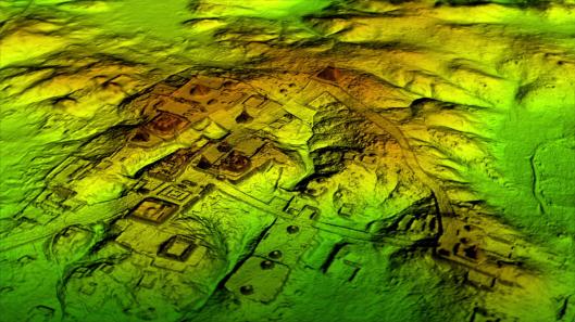
LiDAR data can be processed to digitally remove the forest canopy and reveal ruins below that have long been overlooked. Now we can see that Mesoamerican cities such as Tikal were much larger than scholars realized based on ground-based exploration.
The data from aerial LiDAR over Mesoamerican regions has been truly tantalizing. As National Geographic reports,
In what’s being hailed as a “major breakthrough” in Maya archaeology,
researchers have identified the ruins of more than 60,000 houses,
palaces, elevated highways, and other human-made features that have been
hidden for centuries under the jungles of northern Guatemala
Using a revolutionary technology known as LiDAR (short for “Light
Detection And Ranging”), scholars digitally removed the tree canopy from
aerial images of the now-unpopulated landscape, revealing the ruins of a
sprawling pre-Columbian civilization that was far more complex and
interconnected than most Maya specialists had supposed.
Magleby cites some of the results that might be of interest to Book of Mormon students:
Richard Hansen’s and Fernando Paiz’ Fundación Patrimonio Cultural y Natural Maya (PACUNAM)
just went public with the results of the largest LiDAR survey ever
attempted for archaeological research. It mapped 10 tracts totaling
2,100 square kilometers in the Mirador Basin and other areas of northern
Guatemala. The surveyed area is less than half the size of Utah County.
And what did archaeologists find buried in the Peten?
- 60,000 previously unknown structures
- vast networks of highways elevated so they functioned even in the rainy season
- ubiquitous fortresses, ramparts, and defensive walls
- waterworks including dikes, dams, canals, and reservoirs
- agricultural terraces with irrigation systems
- animal pens
- stone quarries
It will take decades to study so many new sites, but settlement patterns and big picture insights are already apparent.
- Maya lowland population at apogee could have reached 15 million Mormon 1:7
- Maya civilization was much more complex than previously thought Jarom 1:8, Helaman 3:13-15
- Maya cities were more interconnected than anyone realized 3 Nephi 6:8
- Food production was on an industrial scale Helaman 6:12
- land use was intensive – nearing 100% utilization is some areas Mormon 1:7
- Many people lived on marginal, swampy lands 4 Nephi 1:9
- Endemic warfare over centuries was the norm Mormon 8:8
- Warfare was particularly prevalent in the early classic AD 250-500 Moroni 1:2
This northern Guatemalan LiDAR project will continue in phases,
eventually mapping more than 5,000 square kilometers (about the size of
Utah County). At that point it will have mapped approximately 1.4% of
the ancient Maya area which covers 350,000 square kilometers (about the
size of Montana).
This new work also reveals to a serious blunder I’ve made in emphasizing the infancy of archaeological exploration of Mesoamerica to counter absence of evidence claims that Mesoamerica is well understood and leaves no room for Book of Mormon peoples. I’ve previously quoted others to the effect that less than roughly 10% of archaeological sites in Mesoamerica have been excavated. Now that we are realizing that the extent of ancient civilization in that region is far more advanced and complicated than scholars had imagined, it may be better to say less than 1%. It will take decades or centuries to sort through the treasures of knowledge that we have been missing. That doesn’t mean we can expect easy answers to the toughest Book of Mormon challenges, but the century-plus trend of laughable items periodically becoming more plausible might not be over yet. In any case, what a world of knowledge remains to be explored, whether it has any relevance to the Book of Mormon or not. Exciting times are ahead, if we can keep research going and have enough political stability in those lands for the work to be done.
Something that even critics of the Church should notice is that faithful Mormons tend to look forward to more archaeological exploration in proposed Book of Mormon lands. We want more scrutiny, more data, more research, more science, not less, and it’s been that way for a long time. Ditto for exploration of the Arabian Peninsula, where some of us hope to learn more about places that may be relevant to Lehi’s Trail, but are also significant in their own right. Some impatient enthusiasts have been frustrated with unanswered questions, but in many ways the advances in knowledge have been helpful and have been useful in better appreciating many Book of Mormon issues. Witness John Sorenson’s Mormon’s Codex and An Ancient American Setting for the Book of Mormon or Brant Gardner’s Traditions of the Fathers. There is much we can learn by looking carefully at Mesoamerica as well as by looking in the Book of Mormon for Mesoamerican influence.
Back to LiDAR, here is a section from Wikipedia’s article on LiDar that discusses archaeological applications:
Archaeology
Lidar
has many uses in archaeology, including planning of field campaigns,
mapping features under forest canopy, and overview of broad, continuous
features indistinguishable from the ground. Lidar can produce high-resolution datasets quickly and cheaply.
Lidar-derived products can be easily integrated into a Geographic
Information System (GIS) for analysis and interpretation.Lidar can also help to create high-resolution digital elevation
models (DEMs) of archaeological sites that can reveal micro-topography
that is otherwise hidden by vegetation. The intensity of the returned
lidar signal can be used to detect features buried under flat vegetated
surfaces such as fields, especially when mapping using the infrared
spectrum. The presence of these features affects plant growth and thus
the amount of infrared light reflected back. For example, at Fort Beauséjour
– Fort Cumberland National Historic Site, Canada, lidar discovered
archaeological features related to the siege of the Fort in 1755.
Features that could not be distinguished on the ground or through aerial
photography were identified by overlaying hill shades of the DEM
created with artificial illumination from various angles. Another
example is work at Caracol by Arlen Chase and his wife Diane Zaino Chase. In 2012, lidar was used to search for the legendary city of La Ciudad Blanca or “City of the Monkey God” in the La Mosquitia region of the Honduran jungle. During a seven-day mapping period, evidence was found of man-made structures. In June 2013, the rediscovery of the city of Mahendraparvata was announced.
In southern New England, lidar was used to reveal stone walls, building
foundations, abandoned roads, and other landscape features obscured in
aerial photography by the region’s dense forest canopy. In Cambodia, lidar data were used by Demian Evans and Roland Fletcher to reveal anthropogenic changes to Angkor landscape. In 2018, archaeologists using lidar discovered more than 60,000 man-made structures in the Maya Biosphere Reserve, a “major breakthrough” that showed the Maya civilization was much larger than previously thought. [emphasis added]
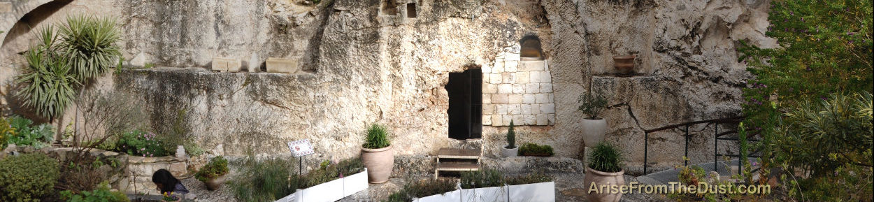
I’m looking forward to more light from LiDAR or any other method being shined on Mesoamerica, the spot where, in my opinion, ancient traditions of written language, vast ancient civilizations, a narrow neck of land, the presence of volcanism, and many other factors make it the only reasonable candidate to consider for a plausible New World setting for the Book of Mormon.


Im excited about this technology. I think in large part the entire Yucatan was the megalopolis. Im a believer these are Jaredite lands and I look gorward to further research.
The dates just don't line up.
Joseph got all his ideas for this stuff from contemporary wishful thinking.
There was NO literal tower of Babel. No serious scholar believes that actually existed, therefore no Jaredites. Nonsense. Let science handle this. Stop picking through their actual work to confirm your own ridiculous biases.
The Book of Mormon did not happen.
I do not concern myself with much of what science has to say with their dating and evidences. I find it most interesting that as they continue to research and find out how greater and greater the Mayans actually were they keep having to change their story.
The Book of Mormon on the other hand will remain, unchanging, as a testimony of truth, of perhaps the greatest civilization in the history of man- that of the great Jaredite civilization.
No literal tower of Babel — do you mean there is no foundation to any aspects of the ancient tradition in several variations? Or do you mean that the modern assumptions of sudden language change that you might read into the story in Ether 1 are obviously wrong? The real problem here is the tendency to make simple assumptions about a text without considering other possibilities. For starters, please see Jeffrey Bradshaw's excellent analysis of this issue in part 4 of a series he produced for LDSMag.com. Part 4 is "Tower of Babel: What did it really mean to 'Confound Their Language'?". It's important to dissect what we read into the account from what the Book of Mormon indicates the Jaredite record actually said.
… the greatest civilization in the history of man- that of the great Jaredite civilization.
Well, maybe the greatest civilization in Joseph Smith's legendarium.
I wonder how the Jaredite civilization stacks up against the Galactic Empire, as revealed to us by the noted historian George Lucas; the Seven Kingdoms, chronicled by another inspired historian, George R. R. Martin; and of course the various civilizations of Middle Earth….
Coruscant and Stygeon Prime, Valyria and Slavers Bay, Mordor and the Shire, Zarahemla and the River Sidon — all the same to me. Which is to say, wondrous tributes to the wondrous powers of the human imagination! This comment is not a criticism of Joseph Smith, placing him as it does in some rather august company; think of it, rather, as just a different kind of Praise to the Man.
— OK
A better analogy would be to the Steed family of "The Work and the Glory" book series. Historical fiction would be the way to go.
Here is an interesting post on where early church leaders, especially Orson Pratt, knew the Book of Mormon lands to be. Read both parts of the blog post. Interestingly, all the early church leaders knew the Book of Mormon lands were in South America and not Mesoamerica. This is worth a read. I loved the thought of Mesoamerica being the site of the Book of Mormon but there are very strong evidences for South America as well. I think that keeping an open mind about both is a good thing. But like I said, this is a good read. I think the biggest thing that I have a question on about Mesoamerica is that in the Book of Mormon, Mormon clearly talks about four seas. The sea north, the sea south, the sea east and the sea west. In Mesoamerica I can see were there would be a north and south, but not an east and west. And these are talked about a lot. I guess I need to look further into the Mesoamerica theory as well. But some things just don't make any sense with it. This is pretty cool thought, I have to admit.
Sorry, forgot the link:
http://nephicode.blogspot.com/2018/02/orson-pratts-message-of-lehis-travels.html
I'm really intrigued by these recent findings. The paradigm that mesoamerican civilizations didn't have flocks, didn't have defensive fortifications, didn't engage in large scale warfare, and weren't that large needs to be reevaluated. Once again the BoM is right on about these points
A lidar is a modern technology used to collect data to measure the distance. There are so many companies that provide lidar service in Alberta. But Onsite 3D provides the best Lidar service in Alberta among them. Lidar Grand Prairie, Alberta
Great points there, thanks. And here is the relevant article, maybe someone will find it useful too
https://cgifurniture.com/3d-product-modeling-companies-furniture-marketing/